Kyorisoku – New Mapion Feature
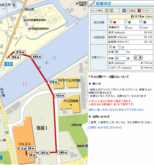
Mapion is my favorite map site for Japan because of its huge-resolution BB (broadband) maps and excellent GUI. I was on the site today looking up directions when I noticed a new feature – distance measurement! Basically, you plot a course on a map by drawings points with your cursor and the distance between each point as well as the total are calculated in a handy little table, which also shows estimated time and calories burned if you walk, jog, ride a bike, or drive the route you plotted.
For instance, this is what it would look like if you walked out of the men’s restroom of Jusco (Sumoto branch), crossed the parking lot, ran to the nearby Sumoto river, and walked over water to get to the nearest Mobil gas station:

(click to see full size)
Unfortunately, there’s no info for performing that last miracle – but remember, IT’S STILL IN BETA. Let’s see if Mapion can include that, plus wind resistance, blood-type factors, and gravitational pull of passing delivery vans in the next version, k? Until then, you can see just how long it takes to get from my corner (where the nearsighted old man and his wife attempt to hawk wilted cabbage to all who pass) to anywhere else in Japan…
I think this new feature will be damn useful for planning bank heists.


3 Comments
Gaijin Biker
That is awesome. I use Mapion all the time, so I will be sure to check this out.
Ben
Now if they only had an API for Movable Type right? Since they don’t, I’ve been working with the MTGoogleMaps. The author and I have come up with a way for using it to embed maps in Japan into individual entries. Check it out on my blog if you like.
Justin
Yeah the MT post integration you wrote about will definitely be useful, but you really have to sign up for the Mapion Labo feature to see what’s possible – I’m not advocating the use of either site exclusively, though. Kind of silly to limit one’s choices at this point because it’s all just starting from now! I can’t wait to see if/what role these mapping services will play in our everyday lives in a few years.