
Back at home, the majority of people are pretty good at giving directions by using street names. You need to be aware of street names, landmarks, and where things are because its an important part of the culture of California. Although driving is also the main way that everyone gets around in these parts, it’s not the same in Kumamoto or in Japan from what I have gathered trying to get my bearings for the past year and nine months since I got here. Most people don’t know street names, and some don’t even recognize the route 3, 11, or the 57 by their names. This would be like not knowing the names of the I-5, 405, or the 101 back home!
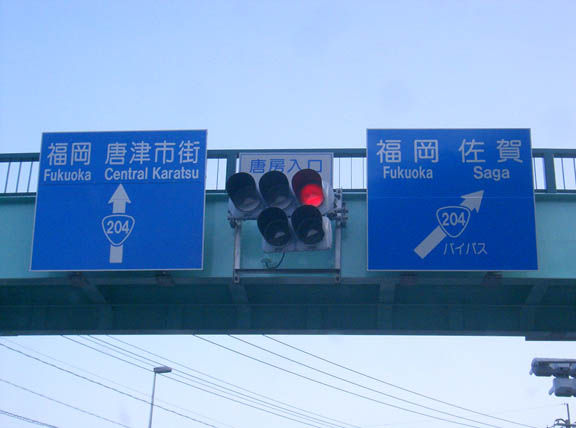
One of the reasons why people don’t remember the names is because they are stupidly marked. If a friend gave the directions to “take the 204 to Fukuoka, and you will find the place on the side of the road”, then you might well pick the wrong 204 and never find the place until you reached Fukuoka and realised that it might have been on the OTHER 204. Idiotic. I mean, you could clarify by saying “take the 204 to the right by the bypass”, but why should you have to. How hard is it to change the name of one of the roads?
My favorite road, the Milk Road, is also marked in a confusing manner. From its spawn point at the Yamanami highway (the 11) it heads off West as the 45 for about fifteen kilometers. Then, for no apparent reason it becomes the 12 for about a ten kilometer stretch, and then reverts to the 45 once again, terminating in Kikuchi (on the 387) after passing through the Gorge (a highly recommended drive!). This is why I think people prefer to use landmarks instead of street names to navigate. The only constants that people will most likely know of are the various legs of the Kyushu expressway, the 3, the 11, and the 57.
Landmarks work surprisingly well, but can also be confusing if improperly used in giving directions. If someone tells you to perform an action (such as turn, go past, etc.) at a conbini (convenience store) then you better get supplemental information. There are so many Lawsons, Family Marts, and 7-11s in close proximity to eachother that navigating by these alone is likely to get you lost.
My friend Jason Wians takes giving directions by using these methods to extremes. The first time I was coming to his house he said the following:
“From Aso, go towards the airport (in Mashiki). Pass the airport, and two or three signals after you will see some ostriches on the left. Turn left. When you see the Everyone (conbini) take a left. Keep going straight until you see some vending machines (this is like saying keep going straight until you see a tree) and turn left. Go straight until you see a hoikuen, and take the right just before you pass it. Take a left at the dog and a right after the old man, and my house will be on the left. Alright, good luck. Yeehaw! Texas rules!!! (which is how he ends every conversation that he has)”.
Well, I followed the directions and got there with no problems! Go figure. Had he used the street signs I might have gotten lost, as the “left at the ostrich” street and the next street are both called the 235 and run parallel to eachother for a great distance.
Signs With No Meaning
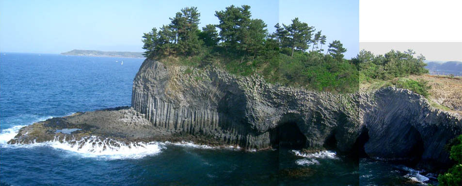
View Full of Aso on the 45
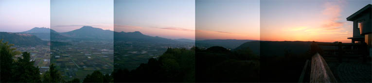
Click the image to see a larger version.
This is my most recent attempt at a panoramic collage. I live ten minutes from this beautiful vantage point, perched along the Yamanami Highway in Northern Aso. People say that these mountains look like a sleeping Buddha. The Eastern (in the left of the picture) peaks of Neko-dake are the head, and the feet point to the South.
You can tell by looking around that this is a special place. If you imagine what must have happened on a geological timeframe to create the largest caldera in the world (the towns of Ichinomiya and Aso below in the valley lie in this caldera), and what forces must have erected the proud mountains in the middle it sends shivers down your spine. If you are interested in geology, seismology, or fields related to these I think that you would enjoy visiting Japan, bust especially Aso-gun in Kumamoto-ken.
I really like this picture, so I included a larger version below that I layered differently. A tip on photographing around Aso- the air is much clearer the day after it rains hard, like the day that I took these shots.
Kyushu Hitching Pics
Hitching at night time was difficult. I would not want to pick up someone who looked like this, but surprisingly people almost always stopped for us regardless of the time or the place. If you get stuck out in the country at night, though, you may have to set up camp.
This is my hitching partner, Mr. Jamie Mackay of Georgia. For some unknown reason, I prefer to introduce him as “James” (no one ever calls him that) to Japanese people.
There And Back
These past 5 days are stretched across my mind like a speedo straining to cover a bulging German tourist. Yes, I’m back safe from hitchhiking, and it was a great experience. However, three full days of rushing around getting picked up by kind strangers were enough for us. I will write more on this later.
Two days ago, we got back to Kumamoto, partied in the city (it was kind of cool because all of the gaijin that we saw were not our familiar locals. being incognito at home is interesting). The next day, we got back late to Aso and headed out to a music festival on the mountain. It was held at a huge clearing in the forest, and it was raining off and on. People had come from all over Japan and had set up a commune of tents, yurts, tee-pees, and other forms of mobile habitation. It was amazing seeing so many gaijin in Aso, along with Japanese hippies and little kids running around amid this strange environment full of the sounds of djembes, dijaradoos, jews harps, reggae music, and a shakuhachi (I only knew what it was thanks to Zachary Braverman’s posts on the subject, and I had a feeling the old dude was good because his beautiful songs sounded like a floating/effortless/improvisational jam session).
I had a great time talking with the people at this festival. Everyone was friendly and it was easy to communicate with them in Japanese or English. The bands were pretty good too, and most of the people at the concert played at least one instrument well. This is the group of people that Taro would be partying with, if he were not married right now.
Last night was the second night that we camped over on the mountain. It had been raining the past couple of days (one of the reasons for truncating the hitchhiking trip), but last night a typhoon rolled over us. I was in my tent thinking about how great my tent was, how it had always been an extremely reliable piece of equipment, and that it only cost 2000 yen. Until last night, it performed flawlessly. However, the winds picked up, gusting across the camp ground, laying waste to our shanty town. The hippies got excited and started to pound on their drums, climaxing when the torrents poured down at their most furious. It blew my tent so hard that the support rods were slapping me in the face and feet. At times, the tent wrapped around me and I felt like I was returning to the womb. I compensated by placing my bag next to the rod that was punching me, and was able to fall asleep in the middle of a raging storm. I remember thinking that the sheets of rain that the wind was driving against my tent’s rain cover was eerily similar to the turbulance portrayed in the Twilight Zone episode “Nightmare at 20,000 Feet”- you know- the one with the gremlin tearing apart the airplane wing and William Shatner! I sure do miss the old school episodes of The Twilight Zone). And then I woke up abruptly when the wind finally tore the cover off of my tent, exposing the windscreen (remember, water and wind can pass through a windscreen, but not a windshield) to the blowing downpour. The experience was similar to gunning through the hypothermic chop in a whaler when the hull smashes into a huge wave which is then blown directly into your face. SMACK! “Fuck this! I live close to here, and I want to sleep in a warm futon tonight!” was my immediate resolve. I woke up Jamie (who was still sleeping somehow), and we made a hasty retreat with some other friends back to his place, coming in from the cold. Many others decided to leave the grounds as well, and it was crazy witnessing the devistation amid the campsite. It seemed as if the fog of war had descended upon our hippie commune, and God was punishing the wicked hippies and gaijin. Most tents were clearly not made to cope with such adverse conditions and had collapsed. Only the yurt and teepees stood proudly, taking everything that the storm was throwing at them.
When we were driving back, I could not help but wonder how the other hitchhikers were faring. We were close to home, and so we just headed back to shelter when conditions got insane. Any hitchhikers caught in the middle of nowhere that might have been forced to camp will no doubt be feeling pretty wiped and soaked right about now. Traveling funk is inevitable, tolerable, and not necessarily a bad feeling, but soaked traveling funk does not sound like fun. Anyone picking up a soaked hitchhiker is indeed a kind soul, because that car packed with soggy gear and soggy gaijin is bound to smell like a wet sheep dog.
The Circuit
Day 1
1. Uchinomaki to Mashiki (thanks to the fireman who spoke super-thick Higo-ben
2. Mashiki to Fukuoka (thanks to the computer salesman and his two sons from Fukuoka, on their way back from a soccer game)
3. Tenjin to Karatsu (Walked 20 minutes towards Saga and got picked up by soapland enthusiast in fixed up black Odessey)
Crashed at Luke’s house and met Joe. The “Joyfull incident”.
Day 2
Started off from 3:00 at onsen near Karatsu.
4. Karatsu to Sasebo (thanks to the old painter)
5. Sasebo to Takeo (thanks to the two college dudes. Jun, maybe we’ll make it out to Nagasaki or Fukuoka sometime!)
6. Takeo to Ureshima (thanks to the electrician who fixes security systems. thanks for offering to let us crash in your van for the night)
Set up tent near the expressway in Ureshima
Day 3
7. Ureshima to Omura (thanks to my Japanese dad, Mr. Tanaka, who lives in Karatsu. I dug your old integra- reminded me of my old legend.)
8. Omura to Nagasaki City (thanks to the bus driver driving the bus to pick up rent-a-car customers. Props for dropping us off right in front of the atomic bomb museum)
9. Nagasaki City to Ariake (we walked out of the city towards Unzen for half an hour in the rain, past the expressway entrance. a salesman, one Mr. Hamasaki, who was closing up his used car lot took pity on us, and told us he would take us to somewhere where we would get picked up, but then decided to drive an hour out of his way to get us to the ferry in Ariake. we had a very nice chat, and he was very embarrased to accept a 5 dollar bill as a memento of our ride together. Mr. Hamasaki called up the ferry, and got us to the last one bound for Kumamoto. While en route to Taida, a port 45 minutes North of the city, he called the ferry to make sure that we were all right! Thanks for helping us out with so much- you were by far the most awesome person that we met on the trip.)
Taida to Kumamoto city- train ride. There was no traffic heading towards the city.
Hitchhiking Kyushu
Jamie and I will be starting out on a 6 day hitchhiking trip from today, planning to reach all of the prefectures in Kyushu. Supposedly this is a friendly competition with several teams from all over Kyushu doing the same thing in order to raise money for charity, but I’m doing it because it sounds like a great way to spend Golden Week.
Packing list:
Jansport backpack,
toiletries,
clothes,
assorted tools and maps,
camera,
tent and sleeping bag,
a towel
Expect another barrage of posts when I return on the 5th of May. Until then, I don’t think I will see many opportunities to get online. Over and out.
The Oita Coastline
Despite for all of the problems with this composite photo, I decided to post it. I know that the shot on the right was overexposed, and that all three of the pictures do not match up nicely (argueably I only need to use two of the photos, but what the heck), but I am learning from my mistakes. This is merely me experimenting with a new format, and any suggestions you may have dealing with a technical nature would be appreciated.
I found this post at luminous-landscapes.com especially helpful for explaining what the histogram function on cameras should be used for. Slowly I am learning how to properly use my camera.
A Few Diving Pics
These were taken at Zamami (jima, I think) at Dragon Lady point.
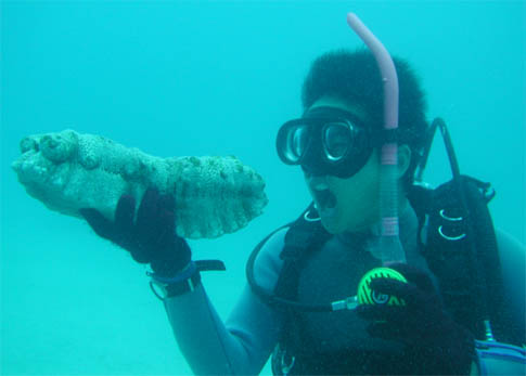
Have you ever seen a sea cuke eviscerate? Not pretty…

These pictures were taken by our guide, a cute 24 year old Okinawan. This one is of some kind of grouper. I want a pet grouper one day that will live under my private dock.
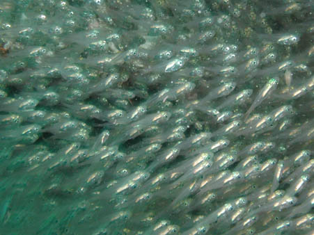
These small silver fish moved as if controlled by some hivemind. Seeing them move as one really hits home the elegant simplicity of the lateral line. Their mass coordinated movements look so complicated, yet are controlled by a really primitive organ that senses differences in the pressure of the surrounding water.
Saga In Bloom
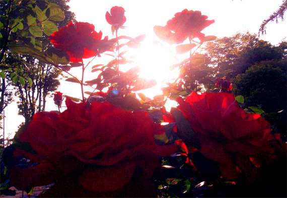
If you have read The Da Vinci Code by Dan Brown, then you will immediately notice that this picture is bursting with multilayered feminine symbolism. On a side note, I enjoyed reading The Da Vinci Code, but I didn’t think it was as good as everyone said it was. For some reason I was expecting the cryptography to be roughly on par with Cryptonomicon. I had a hard time accepting that the “codes” were so easy to solve. I mean, it’s not a very good code if I can come up with the answer on my own soon after I read it. Writing a riddle backwards??? I mean, I everyone knows that Da Vinci wrote backwards sometimes, but how could you not immediately recognize this? Especially if you have watched Buckaroo Banzai.
It’s not that I don’t think that an ultra secret society such as the Priory of Sion wouldn’t use riddles to test the knowledge of others inducted into their ranks to preserve their secrets. I just think that they would ALSO use at least a 4096-bit encryption key to protect the comparatively easy riddles. And the cryptex just sounds like some glorified bicycle lock to me- something that would hack it in Da Vinci’s time, but surely not today. Some crafty cutting could open that thing up no problem without cracking open the vile of vinegar.
OK, getting back on track: The roses (the symbol of Mary Magdeline, or the wife of Jesus Christ according to the book) are arranged in a pentagram (again, according to the book Venus, originally Aphrodite- the goddess of femininity- draws a perfect pentacle across the night sky every four years which the aincent Greeks decided to commemorate with the Olympics). But since this is Japan, Amaterasu is shining away in the center for good measure. There is so much feminine power in this picture that merely looking at it might cause some women to ovulate!
Nanohana
This post is for Uncle Rocky, who requested me to put up some pictures of nanohana. Merin sent me this first picture, which I think was taken somewhere in Kansai. The fields of nanohana evoke memories of mustard back home.
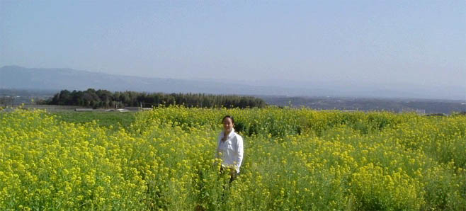
However, the best views of nanohana I have encountered have been down in Kagoshima, during the Nanohana Marathon. In the next picture, you can really see how vibrant this flower really is. Keep in mind that this picture was taken indoors under scant flourescent lighting.

This is Akari-chan, one of my pre-school students. She reminds me of Merin because she is usually serious and stubborn on occasion. Only recently has she started smiling and laughing frequently. She is also really good at traditional Japanese dance, at only 5 years old.
Late Snow Hike
As you can probably tell, I have a lot of stuff that I want to post, and not much time to do it. That’s why I’m finally getting around to this hike, which I did on Sunday, April 4th- two days after my birthday and one after our fire drills. I woke up at 6:00 to the sound of heavy rain, and thought that Hieda (Tomoya) sensei would want to cancel due to the weather. To be honest, I was hoping this because I hate waking up early, especially if it means enduring freezing rain and exercise. Fortunately, he was game to proceed as we had planned. As we drove North on the Yamanami Highway onto the plains of Kuju, we noticed that the peaks of Kuju, which were brown and bare just yesterday and had been for the previous three weeks, had been covered in a thick layer of snow over night. We ascended the peaks, and started up the trail. No one else was there, which was very strange for this time of year. All the way up, we treaded through thick, virgin snow, each foot fall producing a pleasant sound that was half way between the squeak of squishing styrofoam and the crunch of pea gravel.
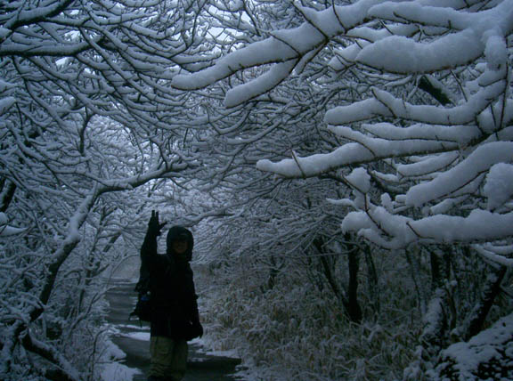
The weather took a turn for the worse, and it started blizzarding. The strong winds slowed our progress, but we made it up in about an hour. At the top, we stumbled upon an emergency shelter, and Hieda sensei made us some ramen and udon with his mess kit. I can’t imagine a better tasting meal, with the wind howling and the snow devils swirling about.
On our descent, we were surprised to see who was climbing the mountain in such weather. About 50 people were climbing up, half of them were groups of retired Japanese, mostly old women decked out in the latest climbing gear. The other half responded to my “Konnichiwa” with a “Ahnyoung-haseyo”. It was really strange practicing rudimentary Korean (just one word, really) in my corner of Kyushu on a snowy day in April.